Fusion Mapping
Developed for utilities, Fusion Mapping is not a traditional GIS. It's a
connectivity engine with a mapping function, not the other way around. It is
streamlined to improve both productivity and accuracy of the facility model
at every step of its lifecycle. Discover a better way to map...
Fusion Mapping is a combination of tools built for the Fusion Framework that
simplifies the management of your network. Using the Microsoft guidelines
for interface generation, you will feel like you’ve been using Fusion for a
long time, even after just a few minutes.
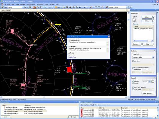
Data Quality Agent (DQA)
In general, data error detection is performed as a batch process, executed
only when the GIS data update work is completed. The data anomalies report
is then reviewed by a GIS technician that finds the problematic objects and
performs the proper corrective action. This cycle might need to be repeated
multiple times, as new errors could be introduced accidentally by the
technician corrects the anomalies identified in the previous report.
DQA constantly validates the data affected by a data manipulation performed
by a GIS technician. If an abnormal condition is created by the result of a
data update, DQA informs the technician of the abnormal result and
recommends a resolution solution.
DQA is designed to reduce the time spent by GIS technicians in the validation
and correction of their work. This interactive tool informs the technician
of data anomalies the instant they are created. By doing so, the data
anomalies can be corrected by the technician, as soon as they are detected
by DQA: it’s like having another data expert assisting you applying changes
to your GIS database content, and keeping it clear of anomalies. It comes
with predefined data validation rules and you can write your own to match
your business rules. It is also possible to define a data validation rule
that will correct data anomalies without any user intervention.
Key features
- Grip points (used to manipulate graphic objects and connect channels to
an equipment)
- Click-and-drag edition
- Smart device insertion on conductors (cut-and-connect)
- Group creation & insertion tools
- Automatic displacement of connected features
- Undo/Redo
Modules
Network
viewer
Fusion Viewer render spatial data from spatial RDBMS. It's
configurable symbology with complex sub-part symbol allows you to
visualize your GIS data in any possible ways.
The Network Viewer can be configure to automatically load the GIS
data within the boundary of the viewer’s viewport, or to rely on the
user to manually load the desired data. This flexibility allows you
to optimize performances and business processes when working in a
specific geographic area.
Background information can be displayed through the use of graphical
files such as DXF or DWG files.
View
datasheet
Network
editor
The Fusion Network Editor is a Distribution Network Information System
designed to accurately model connected networks. It enables utility
companies (electric, gas & water) to manage their distribution network
today and progress with the data modeling demands of the future.
View
datasheet
DQA—Data Quality
Agent
What is DQA?
DQA is a .NET™ based Fusion™ plug-in that dynamically identifies data
anomalies, and suggests potential resolution scenarios. The
validation rules and anomaly resolution algorithms can be customized
to fit the utility’s needs.
Why DQA?
The Data Quality Agent is designed to reduce the time spent by GIS
technicians in the validation and correction of their work. This
interactive tool informs the technician of data anomalies the
instant they are created.
By doing so, the data anomalies can be corrected by the technician,
as soon as they are detected by DQA.
View datasheet
Network
Analysis
Network Analysis is used to analyse the connectivity status of the
equipment—channels and devices—that make up the distribution network
of
your organization. This analysis is done by running a trace, which
displays the connectivity of a network by means of a highlighting
effect.
View datasheet
Theme
editor
Theme Editor is a Fusion™ plug-in that enables the user community to
define thematic views of the Fusion database content, based on the
needs of each user group. Defined thematic views are available to be
used with all Fusion plug-ins installed on any given Fusion
workstation.
View
datasheet
Reporting
Reporting is a module that allows you write, share and run queries on
your data to validate and to interogate the content of your Fusion
GIS database. The results can be displayed in a viewer, a tabular
grid, a browser or exported in other data formats to view them
externally.
Here is a short list of data analysis where Fusion Reporting delivers
exceptional results:
- Connectivity anomaly detection (Parallel feed, loops,
de-energized sections, phase dégradation conditions, etc.)
- Feature relationships analysis (customer to transformer,
overhead equipment to pole, underground equipment to vault,
etc.)
- Construction standards analysis (overhead to underground
connections, wire size and connected equipment, equipment type
and pole class, invalid span length, etc.)
- Spatial analysis (invalid equipment placement, overlapping
feature detection, etc.)
- Other data quality verifications (missing mandatory values,
incompatible attribute values, missing mandatory annotations,
etc.)
Fusion being based on Oracle Spatial, you have access to all the
Oracle spatial functions to analyse your data.
View datasheet